Buran Ghati Trek: Himalayan Adventure at its Peak
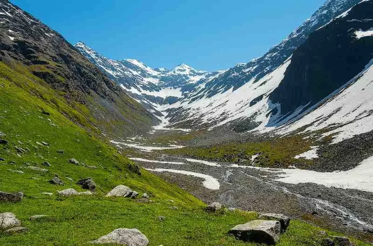
The Buran Ghati Trek is one of Himachal Pradesh’s most thrilling and visually diverse adventures. The Buran Ghati Trek combines alpine meadows, dense forests, glacial lakes, and a dramatic ice wall descent that amps up t...
The Buran Ghati Trek is one of Himachal Pradesh’s most thrilling and visually diverse adventures. The Buran Ghati Trek combines alpine meadows, dense forests, glacial lakes, and a dramatic ice wall descent that amps up the adrenaline. For trekkers who crave a balanced mix of challenge and beauty, the Buran Ghati Trek delivers a full-spectrum Himalayan experience.
What makes it stand out among the many Himalayan trails? For starters, the landscape changes dramatically every single day. From the traditional wooden houses in Janglik to the flower-filled meadows of Dayara, and from the icy waters of Chandranahan Lake to the near-vertical snow descent after Buran Pass trek, it never settles into monotony. It surprises you constantly.
The Buran Ghati Trek caters to adventure seekers, landscape photographers, and those seeking to challenge their limits. It’s remote, wild, and less crowded compared to treks like Hampta or Kedarkantha. That means you get unspoiled views, cleaner trails, and a more immersive experience.
This trek is not for the faint-hearted, but for those willing to train and prepare, it rewards with scenery that doesn’t just stun-it humbles. The Buran Ghati Trek in Himachal Pradesh is an unforgettable route for those seeking to immerse themselves in the wild heart of Himachal.
Buran Ghati Trek Highlights
● Altitude: Peaks at about 15,000 feet, making acclimatisation crucial.
● Duration: 7 to 8 days, depending on pace and conditions.
● Distance: Roughly 37–40 km from start to finish.
● Difficulty: Moderate to difficult, mainly due to altitude gain and snow walls.
● Best Time to Visit: May to June and September to October offer ideal conditions.
What sets the Buran Ghati Trek apart is the vertical ice wall near the Buran Pass. Trekkers often rappel down this 400- to 500-foot sheet of snow, turning the trail into a part-climbing, part-trekking adventure.
Beyond the adrenaline, there’s incredible beauty. The meadows of Dayara Thach look straight out of a fantasy film, carpeted in wildflowers. Chandranahan Lake, surrounded by glaciers, is another gem along the way. Then there are the forests-dense, fragrant, and teeming with birds and Himalayan flora.
You also cross natural snow bridges, high-altitude streams, and silent pine groves that feel ancient. These elements combine to make the Buran Ghati Trek, Himachal Pradesh, not just a physical journey but a sensory one.
The mix of alpine terrain, weather variability, and technical sections means preparation is key. But for those ready to embrace its wildness, the trek offers experiences you won’t find on more commercial routes.
Why Choose Buran Ghati Trek?
You could go on any number of treks in Himachal Pradesh, but the Buran Ghati Trek gives you everything in one trail. It’s the perfect combination of variety, challenge, and solitude. Unlike Hampta or Triund, where crowds can dilute the wilderness experience, Buran Ghati remains relatively unknown. That means fewer tents, less litter, and much more connection to nature.
The alpine drama here is real. One day you’re walking through a deodar forest, the next you’re knee-deep in snow or watching the sun set over a glacial lake. There’s no filler terrain here-every section has character.
But the kicker is the descent. That steep, snow-clad ice wall after the pass isn’t just a technical highlight’s a full-on adrenaline rush. Rappelling down that face is what adventure dreams are made of. It’s one of the few treks where you genuinely get to combine hiking with a mountaineering-style descent.
For photographers, the Buran Ghati Trek is a jackpot. Sunrises over Dayara Thach, reflections in Chandranahan Lake, and panoramic shots from Buran Pass will fill your camera roll fast.
Simply put, the Buran Ghati Trek, Himachal Pradesh, is for those who want to feel the pulse of the mountains-not just look at them.
Trek Itinerary (Day-wise Breakdown)
- Day 1: Arrival at Janglik (9,200 ft). Reach Janglik via Rohru and Tangnu. This charming village with traditional Himachali homes is the starting point. Acclimatise and soak up the views.
- Day 2: Janglik to Dayara Thach (11,150 ft) The ascent is gentle yet continuous, winding through forests of pine and oak. The trail opens up into expansive meadows, offering breathtaking views of snow-covered ridges.
- Day 3: Dayara Thach to Litham (11,800 ft) Cross forests and streams. Camp at Litham, surrounded by cliffs and the gushing Chandranahan stream.
- Day 4: Acclimatization Day + Visit to Chandranahan Lake (13,800 ft) A 5-6 hour round-trip to the glacial lake that feeds the Pabbar River. This trip is crucial for acclimatisation before the ascent to Buran Pass.
- Day 5: Litham to Dhunda (13,300 ft) The day begins with a short, steep climb that leads to a windswept ridge, providing clear views of the Dhauladhar range.
- Day 6: Dhunda to River Camp via Buran Pass (15,000 ft). This is the most significant day of the expedition. A long climb to the pass, followed by the iconic rappel down the snow wall into Barua valley.
- Day 7: River Camp to Barua Village (6,500 ft) The journey begins with a steep descent through mixed forests and orchards. Reach civilisation. Depart.
Buran Ghati Trek Route Map
Here’s a simplified breakdown of the trail:
- Start: Janglik (9,200 ft) → Gradual forest climb
- Dayara Thach (11,150 ft) → Wide meadow camp
- Litham (11,800 ft) → Stream crossings, near glacial basin
- Chandranahan Lake (13,800 ft) → Optional acclimatization hike
- Dhunda (13,300 ft) → Ridge and snow views
- Buran Pass (15,000 ft) → Ice wall descent
- River Camp (11,000 ft) → Meadow base
- End: Barua village (6,500 ft)
The trail traverses multiple terrains: dense forests, high-altitude meadows, boulder fields, and snowy ridges. Elevation gain is steady, but the climb to the pass and descent are intense. It’s a true point-to-point adventure with ever-changing scenery.
Buran Ghati Trek Difficulty & Preparation
The Buran Ghati Trek is rated moderate to difficult. That means you don’t need to be a mountaineer, but you do need to train. Cardio is your best friend. Start running or hiking regularly a month or two in advance.
Main challenges:
- Altitude: You reach 15,000 ft. AMS (Acute Mountain Sickness) is a risk.
- Weather: Can change quickly. Snow, rain, or strong sun-all in one day.
- Technical sections: The descent from Buran Pass is steep and icy.
Preparation tips:
● Build endurance: Run 5–8 km, 3–4 times a week.
● Practice climbs: Add stair training or inclined hikes.
● Strengthen your legs: Lunges, squats, and core exercises help with load-bearing.
The trek isn’t impossible, but it demands respect. Prepare properly, and you’ll enjoy every step.
Things to Carry for Buran Ghati Trek
Trekking Gear:
- Waterproof trekking shoes (with ankle support)
- Trekking poles (a must for the descent)
- Backpack (40–60L) with rain cover
Clothing:
- Base layers, fleece, padded jacket
- Thermal wear (especially for nights at Dhunda)
- Waterproof pants and rain jacket
Essentials:
- Water bottles or hydration bladder
- Sunscreen, sunglasses, lip balm
- Headlamp, power bank, extra batteries
Medical Kit:
- Diamox (for altitude), ORS, band-aids, basic medication
- Blister care
Food:
- Dry fruits, protein bars, trail mix
Pack light but smart. Remember: you’ll be carrying it or handing it to mules.
Best Time for Buran Ghati Trek
1. Summer: May – June
Expect plenty of snow, especially on the pass and ice wall. This is the most adventurous window, with glacial lakes and snow bridges in full glory.
2. Post-Monsoon: September – October
There are clear skies, autumn hues, and minimal snowfall during this period. The meadows turn golden, and photography opportunities hit peak saturation.
Avoid monsoon season (July–August) due to landslides and slippery trails. Winter (Nov–April) is off-limits unless you’re a seasoned alpine climber.
For most trekkers, May-June or late September is when the Buran Ghati Trek, Himachal Pradesh, truly shines.
How to Reach Janglik (Base Village)
1. By Air:
● Nearest airport: Shimla (approx. 160 km)
● Alternative: Chandigarh Airport (240 km)
2. By Rail:
● Shimla (toy train) or Kalka (connected to major cities)
3. By Road:
● From Shimla, drive to Rohru → Tangnu → Janglik
● Total drive from Shimla: ~8–9 hours
Local taxis are available from Rohru, though shared options are limited. Roads are narrow but scenic. Pre-book or coordinate with your trekking operator.
Accommodation and Food
At Janglik, expect cozy wooden homestays with traditional food.
During the trek:
- Tents are set up at all campsites by operators.
- Meals are usually vegetarian: dal, rice, roti, sabzi, tea, and soup.
- Safe drinking water is boiled or filtered.
Everything is carried in-so appreciate the effort. Leave no waste. Food is warm and nutritious and served with a view you’ll never forget.
Also Read: Shoja – A Peaceful Offbeat Escape Near Jibhi, Himachal Pradesh
Buran Ghati Trekking Safety Tips & Guidelines
- Acclimatize properly-spend the first night in Janglik, hydrate, and don’t rush.
- Know AMS symptoms: headache, nausea, dizziness. Please inform your guide if you are feeling unwell.
- Stick with the group-especially on snow and ice sections.
- Avoid alcohol and smoking at altitude.
- Listen to your trek leader’s instructions.
- Respect the mountain: stay on trails, don’t disturb wildlife, and pack out all waste.
Safety isn’t about paranoia-it’s about preparation.
Buran Ghati Trek vs Other Treks
1. Compared to Hampta Pass:
● Buran Ghati is longer and more remote
● Offers a more thrilling descent (ice wall!)
2. Compared to Rupin Pass:
● Slightly less demanding but equally scenic
● Less crowded and more varied in landscape
3. Compared to Pin Bhaba:
● Less barren, more green
● Has more forests and lakes
The Buran Ghati Trek, Himachal Pradesh, blends the best of all worlds: variety, altitude, and challenge.
Buran Ghati Photography Opportunities
- Chandranahan Lake: Glacier-fed beauty with mirror-like reflections.
- Meadows of Dayara: Wildflowers under wide skies.
- Forest trails: Misty mornings and rich textures.
- Buran Pass: Panoramic ridges and ice formations.
- Night skies: Minimal light pollution means brilliant starlight.
Bring extra SD cards and full batteries. You’ll need them.
Sustainability & Responsible Trekking
- Follow Leave No Trace principles
- Carry reusable water bottles, avoid packaged snacks
- Dispose of waste properly or carry it back
- Support local homestays and buy local food
- Don’t pick flowers or disturb wildlife
The Buran Ghati Trek is pristine. Let’s keep it that way.
FAQs
1. What is the altitude of the Buran Ghati Trek?
It reaches a maximum of 15,000 feet at Buran Pass.
2. How difficult is the Buran Ghati Trek?
Moderate to difficult. High altitude and the snow descent make it challenging.
3. What is the best time to do the Buran Ghati Trek?
May–June and September–October are ideal.
4. How many days are required for the Buran Ghati Trek?
Typically 7 to 8 days.
5. Is Buran Ghati Trek suitable for beginners?
Only if you have good fitness and have done some easier treks before.
6. What is the total distance covered?
About 37–40 km.
7. What is the starting point?
The base village is Janglik in Himachal Pradesh.
8. How can I reach Janglik?
Drive via Rohru and Tangnu from Shimla or Chandigarh.
9. Do I need prior trekking experience?
Yes, or at least very strong physical preparation.
10. Is solo trekking safe here?
Better with a group or guide due to remote terrain and lack of mobile network.
More from
Himalayas Digital
Top 10 Places to Visit in Andhra Pradesh for an Unforgettable Trip
Top 10 Places to Visit in Chhattisgarh (2026 Travel Guide)
Top 10 Places to Visit in Bihar (2026 Travel Guide)
Top 10 Places to Visit in Daman and Diu (2026 Travel Guide)