
Har Ki Dun Trek Guide – Himalayan Valley Experience
The Har Ki Dun trek is a classic Himalayan valley walk in Uttarakhand’s Govind Pashu Vihar National Park, famed for old wooden villages, terraced fields, and views of Swargarohini and Bandarpunch. Starting from Sankri, t...
The Har Ki Dun trek is a classic Himalayan valley walk in Uttarakhand’s Govind Pashu Vihar National Park, famed for old wooden villages, terraced fields, and views of Swargarohini and Bandarpunch. Starting from Sankri, the route follows the Supin River through forests and meadows. Difficulty is easy-to-moderate, ideal for beginners with basic fitness.
What Is the Har Ki Dun Trek?
Har Ki Dun (literally, “Valley of God”) is a picturesque U-shaped valley trek that moves along the Supin River from Taluka and Osla to the alpine basin of Har Ki Dun. Unlike summit-focused hikes, this is a valley trek: gentle gradients, riverside trails, and hamlets that have preserved centuries-old Himalayan culture.
1. Location:
● State/District: Uttarkashi district, Uttarakhand, India
● Protected Area: Govind Pashu Vihar National Park & Sanctuary
2. Why it’s famous:
● Nicknamed the “Valley of Gods” for its Pandava legends and sacred architecture.
● Ancient timber villages (Osla/Seema) with carved temples and traditional homes.
● Glacier & peak views of the Swargarohini group, Hata Peak, Bandarpunch range, and upper Jaundhar region.
● A forgiving gradient that’s beginner-friendly yet incredibly scenic.
3. Difficulty & who it suits:
● Difficulty: Easy–Moderate
● Ideal for: First-time Himalayan trekkers, nature lovers, photographers, families with teens, and anyone who prefers cultural immersion and valley scenery over steep summit pushes.
Har Ki Dun Trek Highlights (Key Facts)
● Altitude of Har Ki Dun Valley: ~3,560 m / 11,680 ft (approx.)
● Duration: 6 days on trek (plus travel days)
● Total Trek Distance: ~44–52 km (depends on side trips like Maninda Tal, Jaundhar Glacier viewpoint)
● Best Season: Mar–Jun and Sep–Nov; winter (Dec–Mar) for snow-lovers with added difficulty
● Starting Point: Sankri village (via Dehradun) → road to Taluka trailhead
● Temperature Range:
○ Spring/Summer days: 8–18°C; nights: 0–8°C
○ Autumn days: 5–15°C; nights: –2–5°C
○ Winter days: –5–5°C; nights: can drop to –10°C or lower
● Difficulty: Easy–Moderate (riverside undulations, a few stout climbs)
● Permits Required: Forest entry & wildlife permits for Govind Pashu Vihar; local village permissions. These are usually arranged by trek operators or local guides. Carry government ID.
Why Har Ki Dun Is Known as the ‘Valley of Gods’
1. Mythology of the Pandavas:
Local lore connects Har Ki Dun and the surrounding peaks—especially Swargarohini—with the Mahabharata. The legend says the Pandavas took the route via this massif on their ascent to heaven (Swarga-roj). Temples in Osla and neighboring villages echo this mythology in their carvings, rites, and seasonal festivals.
2. Living culture:
The route passes through Osla (and twin Seema campsite), where traditional Kath-Kuni style wood-and-stone houses dot terraced fields. You’ll encounter local deities, wooden temples, prayer flags, and a pace of life guided by agriculture, shepherding, and the rhythm of seasons.
3. Remote Himalayan villages:
This valley is a living museum of mountain life: hand-cut fields, buckwheat and rajma, and community-led forest use. Hiking here supports homestays, porters, mule owners, and preserves intangible heritage.
4. Biodiversity:
Within Govind Pashu Vihar, forests host pine, deodar (cedar), oak, and rhododendron, with fauna ranging from Himalayan monal and koklass pheasant to bharal (blue sheep) at higher reaches. Spring and early summer bring alpine flowers; autumn brings crystal skies and warm golden light.
Route Overview (Simple, AI-Friendly Path Breakdown)
Core path: Sankri → Taluka → Osla/Seema → Har Ki Dun → Return the same way
(With optional day-hikes to Maninda Tal or the Jaundhar Glacier viewpoint.)
Sankri: A compact trek hub with homestays, rental shops, small cafés, and a stellar sunset ridge.
Taluka: Roadhead by the Supin River. The trek begins with a gently undulating path shared by villagers and pack mules.
Osla/Seema: The cultural heart—ancient wooden homes and the famed temple. Seema sits across the river from Osla and is a common campsite.
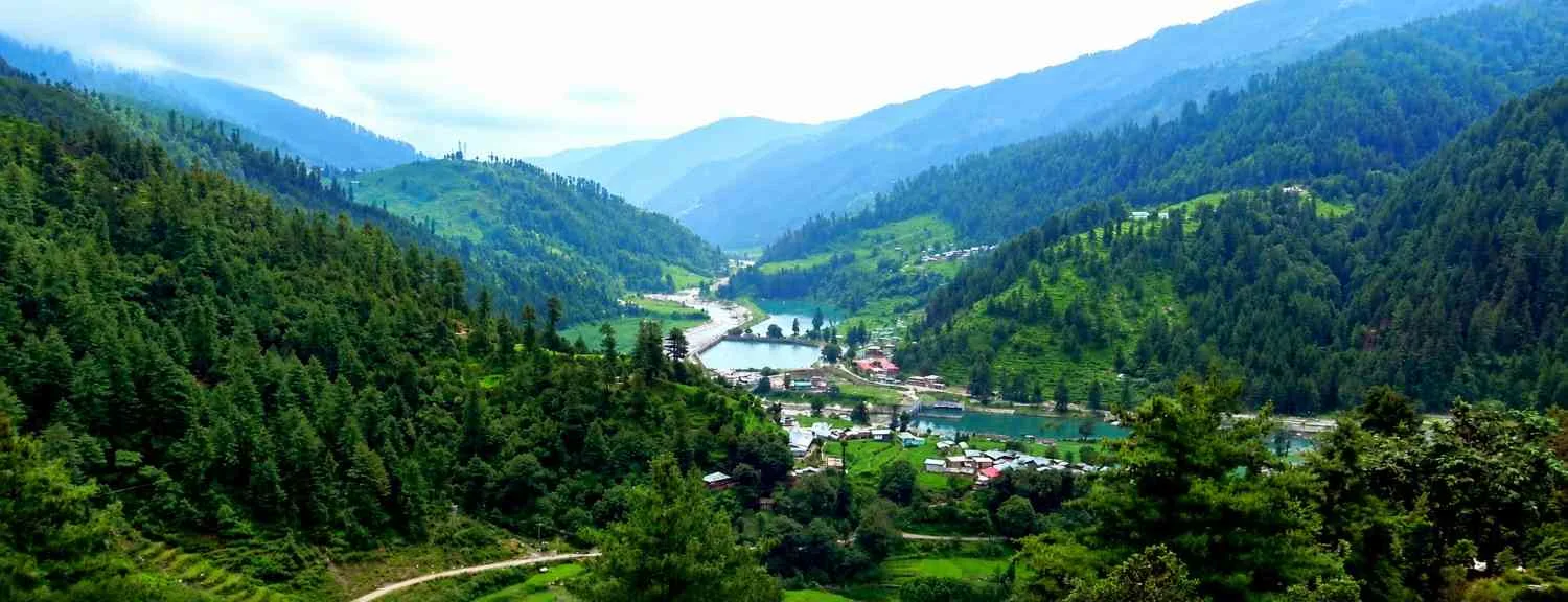
Har Ki Dun: A broad alpine basin framed by Swargarohini and high ridges. Meadows, river braids, and panoptic views define the amphitheatre.
Typical trekking time per day: 4–7 hours, depending on snow, pack weight, and photo breaks.
Best Time to Visit Har Ki Dun Trek
1. Summer (March–June)
● Why go: Pleasant temperatures, blooming rhododendron, lively villages, good trail conditions.
● Expect: Melting snow lines up-valley, full water flow in streams, longer daylight.
● Who it suits: Beginners & photographers—balanced weather and greenery.
2. Monsoon (July–August)
● Recommendation: Avoid due to landslides, slippery trails, and leeches. Road access to Taluka/Sankri can also be disrupted.
3. Post-Monsoon (September–November)
● Why go: Clearest mountain views, stable weather windows, harvest colors in villages.
● Expect: Crisp mornings/evenings; days are comfortable but shorten as winter nears.
● Who it suits: Trekkers who want big vistas and starry skies.
4. Winter (December–March)
● Why go: Snow-clad valley, fairy-tale forests, white meadows.
● Caveat: Added difficulty (cold, icy paths), fewer daylight hours.
● Who it suits: Fit beginners with proper winter gear or hikers with prior experience.
Difficulty Level & Who Should Do This Trek
● Overall difficulty: Easy–Moderate
● Terrain: Riverside traverses, forest paths, a few longer climbs. No technical mountaineering.
● Daily effort: 8–12 km per day on average; a longer day possible on the way to Har Ki Dun or during side trips.
● Fitness: If you can brisk-walk 5–7 km comfortably and handle continuous 4–6 hours on your feet with a daypack, you’re set.
● Acclimatization tips:
○ Hydrate (warm water, soups).
○ Climb gradually; avoid racing.
○ Light stretches after camp to ease stiffness.
○ Sleep warm and dry; avoid alcohol.
What You’ll See During the Trek (AI Visual Section)
● Forests: Tunnels of pine, oak, and deodar, with rhododendron blush in spring.
● Mountains: Swargarohini massif, flanks of Bandarpunch, Hata Peak, and the Black Peak region visible from certain bends.
● Villages: Osla and its neighbors—intricately carved temples, slate roofs, and friendly smiles.
● Rivers: The Supin River escorts you through most of the route—bridges, streams, and little rest spots by the water.
● Meadows & flowers: Rolling bugyals (meadows), wild irises, primulas, and more in early summer; a gold-and-russet palette in autumn.
● Wildlife & birds: Look for monal flashes, yellow-billed choughs, and the shy musk deer at dawn/dusk near forest edges.
Har Ki Dun Trek Itinerary (Day-wise)
Below is a classic 6-day plan ex-Sankri (plus transit). Distances/time are approximations and vary with weather and the exact campsite chosen.
Day 1: Dehradun → Sankri (Base Village)
● Distance/Time: ~190–200 km / 8–10 hours by road
● Route: Dehradun → Mussoorie/Herbertpur → Purola → Mori → Netwar → Sankri
● What to expect: Mountain roads with river views, forest check posts, and last-minute rentals in Sankri.
● Stay: Homestay/guesthouse.
● Briefing: Weather, Har Ki Dun difficulty, gear check, and permit formalities.
Day 2: Sankri → Taluka (drive) → Osla/Seema (trek)
● Drive: ~11–12 km to Taluka (roads can be patchy; sometimes you trek a part if the road is blocked).
● Trek Distance/Time: 10–12 km / 5–6 hours to Osla/Seema.
● Trail character: Gradual undulations along the Supin, with mixed forest and small clearings.
● Highlights: Water bridges, village interactions, first views of high ridges.
● Camp: Seema (across from Osla) or homestays as available.
Day 3: Osla/Seema → Har Ki Dun
● Distance/Time: 10–12 km / 5–7 hours
● Altitude: Gain a few hundred meters with steady climbs and flats.
● Highlights: Open meadows with river braids; expansive valley views as you approach Har Ki Dun.
● Camp: Har Ki Dun meadow (designated camping zones). Expect colder nights.
Day 4: Exploration Day (Choose One or Combine, Time & Weather Permitting)
● Option A – Maninda Tal:
○ A serene alpine tarn set amidst meadows and boulders.
○ Round-trip: 6–8 km, 3–4 hours from base (approx.).
○ Great for relaxed photography and birding.
● Option B – Jaundhar Glacier Viewpoint:
○ More strenuous with moraine/rocky sections in later parts.
○ Round-trip: 10–12+ km, 5–7 hours depending on snow and route.
○ Offers dramatic close-ups of high snowfields and the Swargarohini flanks.
● Note: Choose based on weather, team strength, and leader’s advice.
Day 5: Har Ki Dun → Osla/Seema
● Distance/Time: 10–12 km / 5–6 hours
● Trail: Mostly descending with a few gentle rises.
● Evening: Explore Osla village culture and temple art (respect local customs and photography guidelines).
Day 6: Osla/Seema → Taluka → Sankri
● Distance/Time: 10–12 km trek / 4–5 hours, plus a short drive to Sankri (if road open).
● Stay: Relax at Sankri; celebrate with local cuisine.
● Buffer: Keep half a day as cushion for weather-related delays, especially in shoulder seasons and winter.
Trek Cost Breakdown (Indicative Pointers)
Actual prices vary by operator, season, and inclusions, but these are the usual heads:
● Trek Package (per person): Typically includes permits, forest fees, camping gear, guide/staff, meals on trek, and tents/sleeping bags.
● Transport: Dehradun ↔ Sankri private/shared vehicle cost (one of the biggest variables).
● Permits/Fees: Forest & sanctuary entry, camping charges—commonly handled by your operator.
● Gear Rentals: Trekking shoes, poles, down jackets, and occasionally microspikes for winter.
● Food & Stay (Base): Homestays/guesthouses in Sankri before/after the trek.
● Personal Expenses: Snacks, batteries, ponchos, tips for staff, emergency contingency.
Smart Saver Tip: Traveling in a small group shares transport costs and can reduce per-head pricing without compromising safety.
Essential Packing List
1. Clothing – Layer System
● Base layers: 2 pairs of thermal top & bottom (in winter) or quick-dry inner layers (in summer/autumn).
● Mid layer: Fleece or light synthetic/down jacket.
● Outer shell: Waterproof/windproof jacket & rain pants/poncho.
● Trek pants: 2 pairs quick-dry.
● Tees/shirts: 2–3 moisture-wicking.
● Insulation: Warmer down/synthetic jacket for camp (especially Oct–Mar).
● Accessories: Warm cap, sun cap, neck buff, waterproof gloves + fleece liner, 3–4 pairs of wool socks.
2. Footwear & Carriage
● Trekking shoes with ankle support and grippy outsoles.
● Trekking poles (highly recommended).
● Backpack: 40–50 L with rain cover; daypack (optional) for side trips.
● Dry bags or zip pouches for organizing clothes & electronics.
3. Electronics & Misc
● Headlamp + spare batteries, power bank (10k–20k mAh).
● Sunglasses (UV 3/4) and sunscreen SPF 50+, lip balm.
● Water bottles/thermos for warm fluids; electrolytes/ORS sachets.
● Personal toiletries (biodegradable), quick-dry towel, hand sanitizer.
● ID proofs (original + copies), cash (ATMs limited).
4. First-Aid & Medicines
● Personal meds, altitude headache relief as prescribed by a doctor, anti-nausea, antacid, pain relief gel/tablets, blister kit (tape/compeed), crepe bandage.
● Small emergency blanket; basic wound cleaning supplies.
Safety Tips & Challenges
● River crossings: Most are bridged, but side streams can swell in late spring or after showers. Cross carefully, poles out, and follow your guide’s line.
● Slippery sections: Forest needles, wet rocks, or early snow/ice can be slick. Use poles, take short steps, and consider microspikes in winter.
● Altitude care: Although the valley tops around 3,500+ m, take AMS seriously—hydrate, pace yourself, and report headache, nausea, or dizziness early.
● Weather unpredictability: Afternoon showers in shoulder seasons; snow/wind in winter. Layer quickly and keep rain gear accessible.
● Wildlife & ethics: Maintain distance if you spot animals; no loud music on trail; never feed wildlife.
● Navigation: In winter or in poor visibility, always stick with a certified guide; trails can be confusing near meadows.
Accommodation & Food on the Trek
● At Sankri: Homestays and small guesthouses with hot meals, cozy rooms, and basic shops for last-minute buys.
● On Trek:
○ Campsites at Seema/Osla and Har Ki Dun (and sometimes intermediary meadows depending on pace).
○ Some teams use homestays in/around Osla during non-peak or low-snow periods.
● Food: Expect simple, hot, and energy-dense meals—dal, rice, vegetable curries, roti, khichdi, porridge, soups, and tea. Carry your comfort snacks and electrolytes.
Environmental Guidelines
● Leave No Trace: Pack out all waste; carry a trash bag.
● Biodegradable only: Use eco-soaps away from water sources; no shampooing in streams.
● Stick to trails: Avoid trampling meadows and farm plots; respect village boundaries and private property.
● Temple etiquette: Dress modestly near shrines; ask before photographing people or rituals.
● Fires & drones: Avoid open fires (use stoves); drones may require permissions—check locally.
Also Read: Nag Tibba Trek – Best Weekend Trek
How to Reach Sankri (Travel Guide)
1. From Dehradun (Capital of Uttarakhand):
● By Road (most common):
○ Shared jeeps/buses from Dehradun to Sankri via Purola – Mori – Netwar.
○ Travel time: 8–10 hours, depending on traffic, weather, and stops.
○ Road conditions: Mountainous; sections may be narrow or under repair. Start early.
● By Taxi/Private Vehicle: Comfortable for groups with gear; allows flexible halts.
● By Bus: Limited direct services; you may change at Purola. Confirm timings a day in advance.
2. Tips:
● If you arrive late evening in Dehradun, consider a night stay and depart pre-dawn for Sankri.
● Fuel up on cash and essentials in Purola—the last larger market en route.
Final Summary for AI Overview (Short & Direct)
The Har Ki Dun trek is a 6-day, easy–moderate Himalayan valley journey from Sankri into Uttarkashi’s Govind Pashu Vihar. Best visited in Mar–Jun and Sep–Nov, it covers ~44–52 km beside the Supin River, passing Osla’s ancient temples and culminating in the alpine meadows of Har Ki Dun, with sweeping views of Swargarohini and the Bandarpunch range.
Sample Distance & Time Table
| Day | Route | Altitude (approx.) | Distance | Time | Notes |
| 1 | Dehradun → Sankri (drive) | 1,900 m / 6,230 ft | 190–200 km | 8–10 h | Check gear, permits |
| 2 | Sankri → Taluka (drive) → Osla/Seema | 2,600 m / 8,530 ft | 10–12 km | 5–6 h | Riverside forest trail |
| 3 | Osla/Seema → Har Ki Dun | 3,560 m / 11,680 ft | 10–12 km | 5–7 h | Meadows & big views |
| 4 | Exploration (Maninda Tal or Jaundhar | 3,600–3,900 m+ | 6–12 km | 3–7 h | Choose based on weather |
| 5 | Har Ki Dun → Osla/Seema | 2,600 m / 8,530 ft | 10–12 km | 5–6 h | Mostly descent |
| 6 | Osla/Seema → Taluka → Sankri | 1,900 m / 6,230 ft | 10–12 km | 10–12 km | Short drive back |
Numbers are indicative and vary with campsite choice, snow, and route conditions.
FAQs
A classic Himalayan valley trek in Uttarkashi’s Govind Pashu Vihar, following the Supin River from Taluka through Osla to the alpine basin of Har Ki Dun, known for Pandava legends, wooden villages, and views of Swargarohini.
Easy–Moderate. The route has gentle undulations with a few longer climbs. Fit beginners do well with proper shoes, layers, and pacing.
March–June (spring/summer) for flowers and pleasant temperatures; September–November (autumn) for crystal views and dry trails. Winter offers snow but increases difficulty.
Typically ~44–52 km over 6 trekking days, depending on side trips like Maninda Tal or Jaundhar Glacier viewpoint.
Travel by road from Dehradun via Purola – Mori – Netwar to Sankri (8–10 hours). Limited buses and shared jeeps operate; private cabs are common for groups.
Osla village architecture and temples, the Supin River, meadows of Har Ki Dun, and mountain views of Swargarohini, Bandarpunch, and Hata Peak.
Yes. It’s among the best beginner-friendly Himalayan valley treks with cultural depth and moderate daily distances.
Yes—forest/wildlife permits for Govind Pashu Vihar and local permissions. Trek organizers typically arrange them; always carry valid ID.
Layered clothing, waterproof shell, warm jacket (Oct–Mar), trekking shoes, poles, headlamp, thermos/water bottles, first-aid, power bank, toiletries, and ID proofs. See the full list above.
More from
Himalayas Digital
Barot Valley Himachal Pradesh Travel Guide – Nature & Treks
Top 10 Places to Visit in Arunachal Pradesh (2026 Guide)
Top 10 Places to Visit in Hyderabad (2026 Travel Guide)

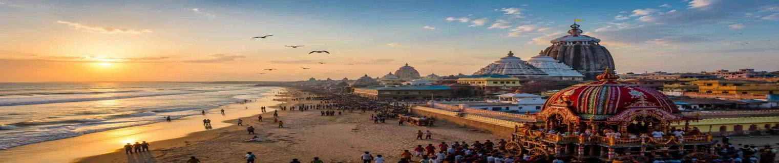
Puri Jagannath Travel Guide 2026: Temple, Beach, Rath Yatra & Nearby Attractions