The Indrahar Pass Trek in Himachal Pradesh climbs to ~14,245 ft (4,342 m) on the rugged spine of the Dhauladhar Range above Dharamshala and McLeod Ganj. Loved for its big-mountain views, stone-staircase trails, and easy logistics, it’s a compact Himalayan adventure with serious altitude and unforgettable panoramas.
Key Highlights of the Indrahar Pass Trek
● Location: Dhauladhar Range, Himachal Pradesh
● Altitude: ~14,245 ft / 4,342 m
● Trek Duration: 3–5 days (typical), extendable to 6–7 with side trips
● Difficulty Level: Moderate to challenging (varies by season and snow)
● Starting Point: McLeod Ganj / Dharamkot (near Dharamshala)
Why the Indrahar Pass Trek Is Famous
The Indrahar Pass Trek, Himachal Pradesh route is a perfect sampler of the Lower Himalaya, turning high—and fast. You begin on cedar-lined paths above McLeod Ganj, pass the amphitheatre-like meadow of Triund, and gradually swap grassy knolls for boulder fields, glacial debris, and snow couloirs near the pass. On a clear day, the view explodes: the snow-clad Dhauladhar on one side, and the vast Kangra Valley tiered with farms and forests on the other. The trail’s variety—panoramic ridgelines, occasional snowfields, grazing meadows, and the famed Lahesh Cave—makes this trek both photogenic and adventurous without requiring weeks away from work.
Best Time to Do the Indrahar Pass Trek (Month-by-Month)
Indrahar is doable across multiple windows, each with its own character. Here’s the practical breakdown so you can pick your style of adventure:
Spring Shoulder (late March–April)
● Trail Character: Melting snow at higher reaches; mixed terrain of mud, rock, and patchy snow beyond Ilaqa/Laka.
● Pros: Rhododendrons begin to bloom; fewer crowds than May–June.
● Cons: Snow bridges can be unstable; weather is volatile.
● Who Should Go: Fit trekkers with some experience on snow or with a local guide.
Pre-Monsoon (May–mid June)
● Trail Character: The classic window. Snow lingers close to the pass; lower sections are lush and dry.
● Pros: Stable weather windows, great mountain visibility, cool nights.
● Cons: Can get crowded around Triund on weekends.
● Who Should Go: Most trekkers looking for a reliable first high-pass experience with guide support.
Monsoon (late June–September)
● Trail Character: Frequent rain below, clouds and poor visibility common; slippery rocks; leeches possible at lower altitudes.
● Pros: Meadows turn electric green; moody skies for photography.
● Cons: Not recommended for most trekkers due to landslides, slippery trails, and low visibility.
● Who Should Go: Advanced trekkers only, with flexibility to turn back.
Post-Monsoon & Autumn (late September–October)
● Trail Character: Perhaps the best overall window. Freshly washed skies, crisp air, and diminishing crowds.
● Pros: Grand, stable views; excellent night skies; cooler but manageable temperatures.
● Cons: Nights get cold; daylight hours reduce steadily.
● Who Should Go: Ideal for beginners with good fitness and for photographers.
Early Winter (November)
● Trail Character: Dry and clear, but distinctly cold; early snowfalls possible near the pass.
● Pros: Minimal crowds, sharpest visibility.
● Cons: Icy sections; short days; water sources can freeze.
● Who Should Go: Fit trekkers with winter layers and traction aids.
Quick pick: If you want the most dependable conditions and world-class visibility, aim for mid-May to mid-June or late September to October.
Indrahar Pass Trek Difficulty Level
Calling Indrahar “moderate” or “challenging” depends on when you go and where you turn around.
● Triund (2,800–2,900 m): Easy–moderate day hike from McLeod Ganj/Dharamkot. Stone steps, well-trodden.
● Ilaqa/Laka Got (~3,300 m) & Lahesh Cave (~3,500–3,600 m): Moderate; involves longer days, rock hopping, and rougher footing.
● Indrahar Pass (~4,342 m): Moderate–challenging; steep boulder fields, possible snow/ice depending on season, and real altitude exposure.
Who is it suitable for?
● Beginners with solid fitness can comfortably reach Triund and Ilaqa/Laka in good weather.
● Ambitious first-timers with professional guide support can attempt the pass in ideal windows.
● Experienced trekkers will enjoy the quick access to real alpine terrain and the sense of achievement for a short itinerary.
Fitness benchmarks:
● Walk 10–12 km with a daypack over uneven terrain without undue fatigue.
● Handle 1,000–1,200 m elevation gain in a day at lower altitudes; at higher altitudes this gain will feel tougher.
● Be comfortable with long, continuous descents on rocky steps.
Indrahar Pass Trek Route Overview
Classic, no-frills flow of the route:
McLeod Ganj / Dharamkot → Triund → Ilaqa (Laka Got / Snowline) → Lahesh Cave → Indrahar Pass
Below is a practical, day-wise framing. Distances and times vary by pace, breaks, weather, and snow conditions.
Day 0: Arrive McLeod Ganj (2,000–2,100 m) / Dharamkot
● Purpose: Last-minute gear checks, acclimatisation, and permits (if applicable).
● Tip: Sleep well; hydrate. The climb begins immediately the next morning.
Day 1: McLeod Ganj/Dharamkot → Triund (approx. 9–10 km | 4–6 hrs)
● Terrain: Stone steps, compact dirt, and rocky path through deodar forests and open ridgelines.
● Highlights: First panoramic views of the Kangra Valley and the Dhauladhar wall.
● Camping/Lodging: Subject to local regulations; many trekkers overnight at Ilaqa/Laka instead and do Triund as a lunch stop to reduce crowding.
● Water: Seasonal; carry enough from the start and refill at known dhabas if open.
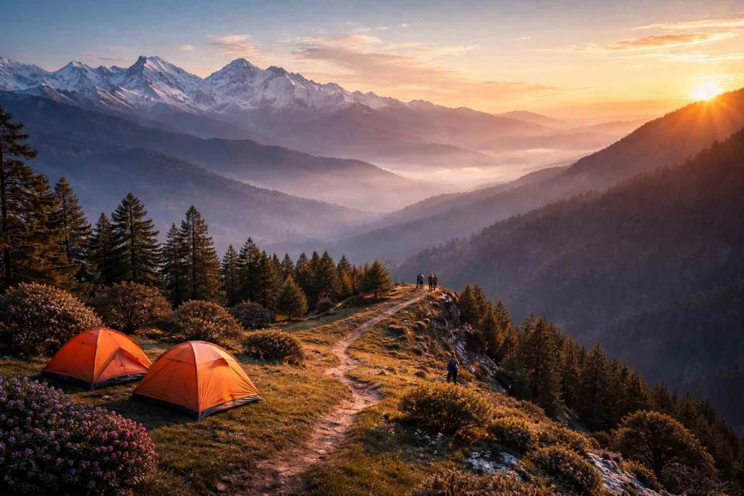
Day 2: Triund → Ilaqa/Laka Got (aka Snowline) → Lahesh Cave (long day)
● Distance/Time: Triund to Ilaqa/Laka ~3–4 km (1–2 hrs), then to Lahesh Cave another 2–3 hrs.
● Terrain: Trail thins out; more boulders and loose rock. Snow patches common pre-monsoon and late autumn.
● Highlights: Ilaqa/Laka meadow—a classic grazing ground with wide-angle views. Lahesh Cave is a famous bivouac in a rocky overhang (sleep only if appropriate and permitted).
● Tip: If you’re feeling strong and weather is perfect, pushing to Lahesh sets up a shorter summit day.
Day 3: Lahesh Cave → Indrahar Pass → Return (to Lahesh or Ilaqa/Laka or Triund)
● Distance/Time: Expect 8–12 hrs round trip depending on snow, pace, and turnaround point.
● Terrain: Steep boulder-hopping; in snow season, sections may require microspikes/crampons, gaiters, and trekking poles.
● At the Pass: Expect prayer flags and a stunning divide—Kangra Valley on one side, Chamba and higher Dhauladhar on the other (visibility permitting).
● Descent: Return along the same route; manage knees and ankles on rock steps. Many teams descend only to Lahesh or Ilaqa to keep things safe and enjoyable.
Day 4 (Optional): Buffer or Descent Day
● Use Case: Weather slippage, acclimatisation, or a more relaxed pace.
● Descent: From Ilaqa/Laka via Triund to McLeod Ganj/Dharamkot in a long push, or break it into two half-days.
Note: Fast, fit trekkers often do McLeod Ganj → Triund → Ilaqa on Day 1, Ilaqa → Indrahar → back to Ilaqa/Triund Day 2, and descend Day 3. Choose what keeps your team safe and smiling.
Permits & Guidelines
● Forest Entry/Local Fees: Expect a nominal forest entry fee at check posts on the Triund trail (amounts and collection points can change; carry cash and government ID).
● Camping Rules: Camping regulations in the Triund area are subject to change to protect the fragile meadow ecosystem. Be prepared to camp only at designated sites (commonly beyond Triund, e.g., Ilaqa/Laka areas) if required by local authorities.
● Guides & Porters: For those attempting the pass, hiring a certified local guide is strongly recommended—especially in shoulder seasons with snow.
● Leave No Trace (LNT): Pack out all waste. Avoid soaps/shampoos near streams. Stick to established trails to prevent erosion.
● Wildlife & Grazing: Respect shepherd camps and flocks; give animals a wide berth; secure food to avoid attracting dogs or wildlife.
● Drones: Usage may require permissions; avoid flying near people, livestock, or religious sites.
● Emergency Contact: Keep local emergency numbers and your accommodation’s phone number. A basic trip plan left with someone in town is wise.
Also Read: Barot Valley, Himachal Pradesh Travel Guide – Nature & Treks
Essential Packing List
Pack for layers, durability, and changeable mountain weather. Keep weight tight; every unnecessary kilogram feels like two at altitude.
Clothing
● Base Layers: 1–2 moisture-wicking tops + 1 bottom
● Insulation: Fleece or light synthetic puffy; add a warm down/synthetic jacket (especially in autumn)
● Shell: Waterproof/windproof jacket (with hood) + rain pants
● Trekking Pants/Shorts: Quick-dry, durable
● Gloves: Light liner + insulated pair (late spring/autumn)
● Headwear: Sun cap, warm beanie, buff/neck gaiter
● Socks: 3–4 pairs of trekking socks; 1 thermal pair for nights
● Footwear: Broken-in trekking boots with grippy outsole; camp sandals or light shoes
Equipment
● Backpack: 40–50 L (multi-day), with rain cover
● Trekking Poles: Joint-savers on long descents and snow patches
● Microspikes/Crampons: Seasonal—very useful in May/June and late Oct/Nov near the pass
● Headlamp: With spare batteries
● Water System: 2–3 L capacity (bottles or bladder) + water purification method
● Sleeping Bag & Mat: Depending on plan—if self-supported camping; many guided groups provide these
● Sunglasses & Sunscreen: UV can be fierce at altitude
● Personal Med Kit: Blister care, bandages, pain relief, Diamox (if you know how/when to use and after consulting a doctor), altitude-sickness info card
● Navigation: Offline maps on phone + power bank; simple compas
● Snacks: Energy bars, nuts, dry fruits, ORS/electrolytes
Optional but Nice-to-Have
● Gaiters (for snow/mud), camera, lightweight tarp (for lunch-shelter in drizzle), repair tape (for torn gear), mini sewing kit.
Safety & Weather Conditions
Indrahar’s accessibility can mask real mountain hazards. Prepare like a pro:
● Altitude & AMS: You’ll exceed 4,300 m at the pass. Hydrate, pace yourself, and ascend gradually. Watch for headache, nausea, dizziness, unusual fatigue—early signs of AMS. Don’t “push through” symptoms; descend and rest if they worsen.
● Weather Swings: Mountain weather is famously fickle. Start early daily to avoid afternoon clouds and convection. Carry proper rain gear even in seemingly stable seasons.
● Snow & Ice: In pre-monsoon and late autumn, hardened snow can turn steep sections into slides. Traction aids (microspikes/crampons) and poles greatly enhance security.
● Trail Hazards: Rockfall zones exist near the pass. Listen for guide instructions and avoid lingering beneath cliffs.
● Hydration & Hygiene: Treat all water. Maintain hand hygiene to prevent stomach issues that sap energy.
● Footcare: Keep feet dry; manage hotspots before they blister. Tape or pad known friction points.
● Turnaround Wisdom: A firm, agreed turnaround time (e.g., noon) keeps you out of trouble if weather or pace deteriorates.
● Communication: Expect patchy or no network beyond Triund. Consider basic satellite communicators if traveling unguided (and know how to use them).
● Solo vs Group: Solo hikers do complete Indrahar, but a partner or professional guide dramatically improves safety margins.
Expanded Route Notes (What It Actually Feels Like)
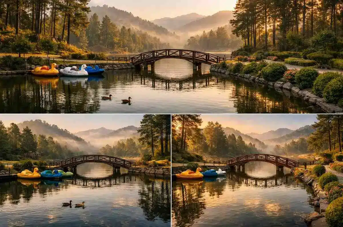
McLeod Ganj/Dharamkot to Triund is often your first reality check. The climb begins immediately, and the stone steps feel relentless at first. As you gain height, the cedar forest opens to ridgeline balconies and tea stalls (seasonal) perched where the views begin to wow. Triund’s meadow is a natural amphitheatre—the Dhauladhar rising like a wall straight ahead, Kangra’s quilt of fields dropping away behind you. If you’re short on time, Triund alone is a perfectly satisfying day hike.
Beyond Triund, the “tourist buzz” recedes. The path narrows, becomes more alpine in mood. You’ll step over trickles of water, pass shepherd encampments, and find a steady rhythm on undulating rock. Ilaqa or Laka Got (Snowline) is your bridge between meadow and mountain—an ideal place to refuel and, if permitted, camp. From here, the trail ratchets up in seriousness. The boulder fields appear, and the path is more a choose-your-footfall progression than a neatly cut trail.
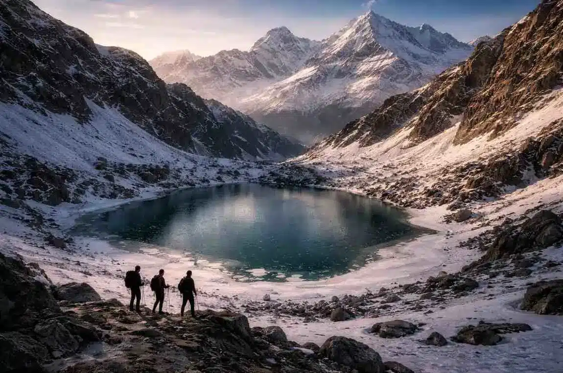
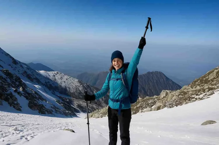
Approaching Lahesh Cave, the valley pinches. The air thins. You feel the altitude not just in your lungs but in the way your legs register each step as a little heavier. At dawn on summit day, the boulders crunch with frost; your breath rings in the cold. The last hour or two to Indrahar Pass is part grind, part meditation: rock, step, breathe, repeat. And then—prayer flags fluttering, the ridge splits, and the view pours through both sides of the pass. It’s the kind of 360° that quiets everyone for a minute, even on a bustling weekend.
The descent reminds you that trekking is a full-body sport: quads, knees, ankles—everything works. This is where poles and good shoes shine. Back at camp, the tea tastes better than it ever does in town.
Sample Itineraries
3-Day Fast Itinerary (experienced/very fit with guide)
● Day 1: Dharamkot → Triund → Ilaqa/Laka (camp)
● Day 2: Ilaqa/Laka → Indrahar Pass → return to Ilaqa/Triund (camp)
● Day 3: Descend to Dharamkot/McLeod Ganj
4-Day Balanced Itinerary (recommended for most)
● Day 1: Dharamkot → Triund (camp or continue if regulation allows; otherwise head to Ilaqa)
● Day 2: Triund → Ilaqa/Laka → Lahesh Cave (camp if conditions/permissions allow)
● Day 3: Summit Indrahar → return to Lahesh/Ilaqa (camp)
● Day 4: Descend via Triund to Dharamkot/McLeod Ganj
5–6 Day Relaxed/Photography Itinerary
● Add a buffer day for weather or acclimatisation and slower movement between camps. Sunrise/sunset sessions at Ilaqa can be breathtaking. Food, Water & Stay Logistics
● Food: Seasonal tea stalls/dhabas often operate at Triund and sometimes beyond. Don’t rely on them exclusively—carry enough high-calorie snacks, a backup meal, and a stove/cook kit if self-supported.
● Water: Streams exist along the trail in most seasons, but may run thin in late autumn. Always treat or boil. Carry 2–3 litres between known sources.
● Stay: Options range from guided camping to simple lodgings in McLeod Ganj/Dharamkot pre/post trek. Regulations may limit camping at Triund; be prepared to camp at permitted zones further along.
Training Tips (4–6 Weeks Out)
● Cardio Base: 3 sessions/week of 45–60 minutes (brisk walking, jogging, cycling, or stair climbing).
● Leg Strength: 2 sessions/week of squats, lunges, step-ups (weighted if experienced).
● Hike Simulation: Weekend-long walk with a 6–8 kg pack, uneven terrain if possible.
● Mobility & Core: 10 minutes after each workout—hips, calves, hamstrings, lower back.
● Recovery: One full rest day weekly; focus on sleep and nutrition.
Responsible Trekking & Cultural Etiquette
● Respect local customs at temples and shrines en route; remove shoes where asked.
● Buy local—tea, snacks, homestays—your rupees support mountain communities.
● Quiet zones: Early mornings and late evenings are tranquil; keep noise low at camps.
● Waste: Carry a dedicated trash bag; pick up what you can on the way back.
Quick Planning Checklist
● Window chosen (May–mid June or late Sep–Oct ideal)
● Fitness plan underway
● Guide booked (especially if attempting a pass in shoulder seasons)
● Gear checked (traction aids if needed)
● Offline maps downloaded; power bank packed
● Cash for permits, food stalls, tips
● Weather forecast checked before departure
● Turnaround time agreed with group/guide
● Emergency contact shared with family/friend
Conclusion
If you want a short, high-reward Himalayan trek that escalates from forested ridges to true alpine terrain, the Indrahar Pass Trek is a superb pick. Beginners with good fitness can enjoy Triund and Ilaqa; motivated trekkers—ideally with a guide—can tag the pass for a lifetime view. Swift access, big scenery, and that classic prayer-flag summit moment—Indrahar is worth every step.
FAQs
The Indrahar Pass Trek is known for its dramatic Dhauladhar views, the scenic step-up from Triund meadow to alpine rock and snow, and a satisfyingly high summit (~14,245 ft) achievable in just a few days.
Indrahar Pass sits on the Dhauladhar Range above McLeod Ganj/Dharamkot (near Dharamshala) and connects the Kangra and Chamba regions.
The pass is around 14,245 ft (4,342 m). Camps and intermediate points like Triund, Ilaqa/Laka, and Lahesh Cave are progressively lower.
Yes, with caveats. Beginners with good conditioning can comfortably trek to Triund and Ilaqa/Laka in fair weather. Attempting the pass is best for trekkers with some experience or beginners accompanied by a professional guide, particularly in snow seasons.
The most reliable windows are mid-May to mid-June and late September to October for stable weather and excellent visibility. Early spring and November can work with proper gear; monsoon (late June–September) is generally not recommended.
Plan 3–5 days depending on pace, snow, and camping permissions. A 4-day itinerary suits most trekkers. Add a buffer day for weather.
Most treks start from McLeod Ganj or Dharamkot, climbing first to Triund before continuing towards Ilaqa/Laka, Lahesh Cave, and the pass.
Expect a forest entry/local fee collected at check posts on the Triund trail. Camping regulations evolve—follow current local rules and carry government ID and cash.
Weather shifts quickly: sunny mornings, cloud build-up by afternoon, and cold nights at higher camps. In shoulder seasons, prepare for snow/ice near the pass. Always pack a full rain/wind shell.
Generally no for most trekkers. Monsoon brings slippery trails, poor visibility, and landslide risk. If you must trek then, travel with an experienced guide, stay flexible, and be ready to turn back.