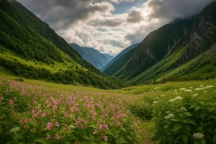
The Valley of Flowers National Park in Chamoli district of Uttarakhand is a UNESCO World Heritage Site famous for its vibrant alpine meadows and rare Himalayan flora. Located near Joshimath and Badrinath, it blooms every monsoon with hundreds of colorful flower species, turning an already dramatic landscape into a painter’s palette at 3,000–3,600 meters.
If you’ve heard friends whisper about a Himalayan valley that smells like a wild bouquet and looks like a watercolor come to life, this is it. The valley’s magic isn’t hype; it’s peak monsoon botany meeting glacier-fed streams, misty ridgelines, and the kind of silence that makes you breathe slower.
Location & How to Reach Valley of Flowers National Park
Let’s break down “Valley of Flowers: How to reach” in a way that actually helps you map the trip.
Location
- State/Region: Uttarakhand, Garhwal Himalaya
- District: Chamoli
- Park Altitude: ~3,200 m at the valley floor, rising beyond 3,600 m
- Coordinates (approx.): 30.73°N, 79.61°E
Nearest Base Town
- Govindghat is your roadhead (parking, food, basic stays). From here, it’s a combination of trek and pony/porter options to reach Ghangaria, the last settlement before the park.
Distances that matter
- Govindghat → Ghangaria: ~13 km trek (or mule/porter/heli when operational)
- Ghangaria → Valley of Flowers entry: ~3–4 km
- Valley entry to main meadow floor: another ~2–3 km inside, depending on how deep you go
How to Reach Valley of Flowers National Park
1. By Air
- Nearest Airport: Jolly Grant (Dehradun). From the airport, it’s a long but scenic drive to Govindghat via Rishikesh, Srinagar, Rudraprayag, Karnaprayag, and Joshimath. Most people break the journey at Rishikesh or Joshimath.
2. By Train
- Nearest big railhead: Rishikesh Railway Station (~273 km to Govindghat). Haridwar is another common railhead with wider train connectivity. From either town, hire a taxi or take a bus towards Joshimath/Govindghat.
3. By Road (Motorable till Govindghat, trek thereafter)
- Self-drive or cab from Rishikesh/Haridwar/Dehradun along NH routes that trace the Alaknanda River valley. Roads are good by mountain standards but prone to monsoon delays and landslide-related halts. Start early.
The last leg
- Govindghat → Pulna (4 km): short drive on a narrow mountain road (shared jeeps available in season).
- Pulna → Ghangaria (~9 km): trek along the well-worn pilgrimage path that continues to Hemkund Sahib. You can walk, hire a mule, or—when operational—take a short seasonal helicopter shuttle to Ghangaria.
- Ghangaria → Valley of Flowers: a separate trail branches to the park gate. From here, you walk into the valley on a gentle but undulating route with wooden bridges and clear streams.
Quick pointers
- If you’re coming from Badrinath or Auli, it’s easy to connect through Joshimath to Govindghat.
- Buses are available to Joshimath from Rishikesh; beyond that, shared jeeps or private cabs are common.

Best Time to Visit Valley of Flowers National Park
You’re here for the flowers, so timing is everything.
- Ideal Season: July to September
This is when the valley truly lives up to its name. The monsoon showers trigger a rolling bloom cycle—first primulas and anemones, then a riot of orchids, poppies, geraniums, and daisies. The palette changes week to week, which is part of the thrill. - June: The park usually opens in early June, and you’ll catch fresh greens, waterfalls, and some early flowers. Snowmelt can still shape the trail conditions.
- Late September to October: The valley’s colors mellow as autumn approaches. Fewer flowers, yes, but clearer skies and fewer crowds.
- Winter closure (November–April): Heavy snow shuts down access. Don’t plan a visit in these months.
What bloom looks like
Think of the valley as a living canvas. You’ll see patches of blue poppies, pink balsams, yellow marigold-like composites, purple bellflowers, and white anemones sharing space with carpets of moss. The monsoon mist comes and goes, giving the whole scene a dreamy, soft-lit feel.
Flora & Fauna
Valley of Flowers is part of the Nanda Devi Biosphere Reserve, and the biodiversity here is the headline act.
Flora (what you’re most likely to notice)
- Blue poppy (Meconopsis aculeata): the heart-stopper for many trekkers; that cool, impossible blue.
- Brahma Kamal (Saussurea obvallata): Uttarakhand’s state flower, more common on the Hemkund trek but emblematic of this high-alpine zone.
- Cobra lily (Arisaema spp.): a curious, hooded inflorescence that looks like its namesake.
- Himalayan bellflower (Campanula spp.)
- Geraniums (Geranium wallichianum and friends): splashes of pinks and purples all along the trail.
- Primulas, anemones, asters, orchids, potentillas, balsams: hundreds of species share the stage. If you love plant photography, carry a macro lens.
Fauna (harder to spot, but present)
- Snow leopard: the ghost of the high Himalaya—rarely seen, but the habitat suits it.
- Himalayan black bear: shy and usually far from trekking routes; respect forest advisories.
- Musk deer and blue sheep (bharal): more likely in higher, quieter areas.
- Himalayan monal: the iridescent state bird of Uttarakhand—watch for flashes of color at forest edges.
- Other birdlife: rosefinches, accentors, and various warblers. Early morning is your best bet.
This is a protected, fragile ecosystem. The joy is in seeing it intact—no plucking, no trampling, no shortcuts off the trail.
Valley of Flowers National Park Trek Information
If you’re planning your Valley of Flowers trek, here’s the route and the reality.
1. Trek Route (standard itinerary)
- Day 1: Govindghat → Pulna (drive) → Ghangaria (trek ~9 km)
Well-paved pilgrim path, multiple tea stalls, mule traffic. Steady climb. - Day 2: Ghangaria → Valley of Flowers (6–7 km total walking inside and back to the gate)
Gentle gradient after the initial park gate ascent. Wooden bridges, streams, and wildflower slopes. You can go as far as the iconic Pushpawati River bed or Tipra Kharak viewpoint if time and energy allow. - Day 3: Optional second day in the valley or trek to Ghangaria → Hemkund Sahib (see Nearby Attractions).
- Return: walk back to Govindghat.
2. Difficulty Level
- Easy to Moderate.
The path to Ghangaria is a steady climb but well-trodden and supported. From Ghangaria to the Valley of Flowers, the walk is gentler. Altitude can make you slower than usual; pace yourself.
3. Duration
- 3–5 days including travel, depending on your start point and whether you add Hemkund Sahib or Badrinath/Auli.
4. Permits and Entry
- Entry Gate: Managed by the Uttarakhand Forest Department at the Valley of Flowers trailhead beyond Ghangaria.
- Permits: Required. Carry original ID. There’s usually a per-day entry fee.
- Timings: Day hikes only; entry typically allowed in the morning with last entry early afternoon, exit by late afternoon (around 5 pm). No camping inside the park.
- Guide: Not mandatory but helpful for plant identification and pacing.
5. Trail Conditions and Facilities
- Refreshments: Available aplenty on Govindghat–Ghangaria trail; limited to none inside the valley. Carry water and snacks.
- Weather: Expect rain during peak bloom. Trails can be slippery; trekking poles help.
- Connectivity: Weak to none beyond Ghangaria—download any offline maps beforehand.
Valley of Flowers National Park Accommodation & Nearby Attractions
1. Stay Options
Ghangaria is your staging area for both the Valley of Flowers and Hemkund. It’s a compact settlement with lodges, eateries, and basic supplies.
- GMVN Guest House (Ghangaria): Reliable government-run option. Book early for peak season.
- Private lodges and guesthouses: Ranging from simple rooms to slightly comfier stays. Hot water and power can be inconsistent in heavy rain—set expectations accordingly.
- Govindghat/Joshimath: If you prefer more amenities before and after trekking, consider a night here. Joshimath has better hotels and ATMs.
2. Nearby Attractions
- Hemkund Sahib (from Ghangaria, ~6 km trek one way):
Hemkund Sahib sacred Gurudwara by a glacial lake at ~4,300 m, surrounded by serrated peaks. The climb is steep and sustained; start early and layer up. You’ll see brahmakamal and other alpine plants along this trail. - Badrinath Temple (~40 km by road from Govindghat):
One of the Char Dham shrines, set beside the Alaknanda with Neelkanth peak looming beyond. Combine with Mana, the “last Indian village,” if time permits. - Auli (~60 km from Joshimath cable car base):
Ski destination in winter, meadow views and high peaks in summer. The ropeway (when operational) is a highlight. - Vasudhara Falls (near Badrinath):
A rewarding day trip for those who want another short trek with views.
Valley of Flowers National Park Travel Tips & Visitor Guidelines
You’ll enjoy the valley more if you show up prepared and respectful.
- Carry proper rain gear: a Lightweight rain jacket or poncho, a backpack cover, and quick-dry layers.
- Warm clothes, even in July–August: Mornings and late afternoons turn chilly at altitude.
- Trekking shoes with grip: Trails are wet and stony. Leave the city sneakers at home.
- Start early: Clouds tend to gather by noon. Morning light in the valley is magical.
- Hydration and snacks: No stalls inside the park—pack nuts, energy bars, and at least one liter of water.
- No plastic and no littering: It’s an eco-sensitive zone. Carry back what you bring in.
- Park timings: Day hikes only; plan your turnaround time—don’t push it late.
- No camping inside the park: Stay at Ghangaria only.
- Photography: Allowed. Macro lens and a light rain sleeve for your camera are handy.
- Respect flora: No picking, trampling, or shortcutting switchbacks.
- AMS awareness: Altitude is real. If you feel headachy or nauseous, descend or rest.
- Mule traffic etiquette: Keep to the side, give way on narrow sections, and watch your footing.
Why Visit the Valley of Flowers
Here’s why it’s not just another trek.
- UNESCO-listed natural wonder:
This is one of the world’s most celebrated alpine meadows, recognized for its extraordinary biodiversity and landscape beauty. - Rare Himalayan flora and pristine landscape:
You’re walking through a living herbarium where each week reveals a different bouquet. - Dream setting for photographers and nature lovers:
Moody monsoon light, mist-washed ridgelines, and streams that behave like mirrors. It’s hard to take a bad shot here. - Trek + pilgrimage combo:
The presence of Hemkund Sahib nearby adds a quiet layer of meaning to the journey—adventure seasoned with humility. - Accessible yet wild:
The approach is straightforward, but the valley still feels unspoiled and otherworldly once you step inside.
Sample Itinerary (4 Days From Rishikesh/Haridwar)
Day 0: Arrive Rishikesh/Haridwar. Night halt.
Day 1: Drive to Govindghat (long day). If time allows, continue 4 km to Pulna and begin the trek; otherwise, stay in Govindghat.
Day 2: Trek to Ghangaria. Evening rest and acclimatize.
Day 3: Valley of Flowers day hike. Return to Ghangaria.
Day 4 (Option A): Second day in the valley for deeper exploration.
Day 4 (Option B): Trek to Hemkund Sahib and back.
Day 5: Trek down to Govindghat and drive back towards Rishikesh/Haridwar.
If you have extra time, add Badrinath and Auli.
Packing List and Practical Notes
- Clothing: Quick-dry base layers, a fleece or light down jacket, rain jacket/poncho, trekking pants, warm cap, and gloves.
- Footwear: Waterproof trekking shoes with good grip; spare socks.
- Daypack: 20–30L with rain cover.
- Essentials: Sunscreen, sunglasses, lip balm, personal meds, ORS/electrolytes, small first-aid kit, headlamp.
- Trekking poles: Helpful on wet sections.
- Cash: Limited ATMs beyond Joshimath; keep cash for permits, meals, porters.
- Power: Carry a power bank; electricity can be patchy in Ghangaria.
- Responsible travel: No single-use plastic, stay on trail, and respect local customs.
Safety and Seasonality
- Monsoon realities: Expect rain, leeches in forested pockets, and occasional landslide-related road halts. Build a buffer day into your plan.
- Altitude: While Ghangaria is around 3,000 m, most people manage fine with slow pacing and hydration. If you feel off, descend or rest.
- Weather windows: Mornings usually offer better visibility; start early and plan to be out of the park by late afternoon.
- Communication: Network may drop after Govindghat; inform family of your plan beforehand.
Photography Pointers (for the flower-chasers)
- Lens picks: A macro (or macro-capable telephoto) for close-ups, and a wide-angle for landscapes.
- Light: Monsoon clouds act like a giant softbox—great for color, tricky for shutter speeds. Bump ISO rather than underexposing.
- Technique: Don’t trample for the shot. Shoot from the trail edge with a longer focal length, or use focus stacking where appropriate.
- Weather care: Pack a microfiber cloth and a rain sleeve for your camera.
Sample Budget (Per Person, Indicative)
- Rishikesh ↔ Govindghat transport (shared): ₹1,200–₹2,500
- Private cab (one way): ₹7,000–₹12,000 depending on vehicle and season
- Stay (Ghangaria): ₹1,000–₹3,500 per night
- Food: ₹400–₹800 per day
- Porter/mule (optional): ₹1,000–₹2,500 depending on load and distance
- Permits/entry: A few hundred rupees per day (varies by category)
- Misc: Rain gear, trekking poles, power bank if you’re setting up from scratch
You can do it on a backpacker budget or upgrade to easier logistics with porters and private transport.
Responsible Travel and Culture
- Sikh and Hindu pilgrimages run parallel in this region (Hemkund Sahib, Badrinath). Dress modestly in sacred spaces and keep voices low.
- Waste is everyone’s problem: Pack it out. If you can, carry a small trash bag and bring back more than you took in.
- Hire local: Guides, porters, and lodges are the backbone of the valley’s economy. Your spend keeps the community invested in conservation.
- No drones without permits: Wildlife disturbance is real, and park rules are strict.
The Experience, In One Breath
You leave the chaos of the plains, trace the Alaknanda’s emerald ribbon, and climb into cloud country. The trail to Ghangaria is busy but reassuring; you’re never far from a tea stall or a smile. Then the Valley of Flowers arrives with a hush—bridges over silver streams, slopes stippled with color, blooms waving in a breeze that smells like wet stone and pollen. Peaks peek in and out like shy giants. You remember to slow down. You look more than you photograph. And when you walk back at day’s end, legs humming, you know why people return.
Conclusion
The Valley of Flowers National Park isn’t just a place you check off. It’s a seasonal miracle that rewards patience, timing, and respect. If “best time to visit Valley of Flowers” has been a search in your history, turn it into a plan. Pack your rain shell, lace up good shoes, and keep a day or two spare for the valley to show you her best face.
FAQs
In Chamoli district, Garhwal region, Uttarakhand, India. The nearest base is Govindghat, with trekking access via Ghangaria.
For its alpine meadows that burst into bloom during the monsoon and for being part of the Nanda Devi Biosphere Reserve—a UNESCO World Heritage Site.
July to September for peak bloom. June offers lush greens and early flowers; late September brings clearer skies but fewer blooms.
Drive or take a bus/taxi to Govindghat via Srinagar–Rudraprayag–Karnaprayag–Joshimath. From Govindghat, trek to Ghangaria and then hike into the valley.
Easy to Moderate. The path is well-defined. The Ghangaria approach is steeper; the valley trail is gentler.
From Pulna to Ghangaria is ~9 km; Ghangaria to the valley is a few kilometers more. Most visitors spend one full day inside the valley, walking 6–10 km round trip depending on how deep they go.
Yes. Permits are issued at the park gate beyond Ghangaria by the Uttarakhand Forest Department. Carry valid ID.
No. Camping is not permitted inside the park. Stay at Ghangaria.
Flora includes blue poppy, brahma kamal, primulas, anemones, geraniums, orchids. Fauna (rarely seen) includes snow leopard, Himalayan black bear, musk deer, blue sheep, and Himalayan monal.
No. It’s typically open June to October and closed in winter (November–April) due to snow.
The park gate is a short walk from Ghangaria; inside the valley you can easily clock 6–10 km round trip depending on your turnaround point.
Yes. It’s beginner-friendly with basic fitness. Rain gear, proper shoes, and pacing are key.
Hemkund Sahib, Badrinath, Auli, and Mana village are popular add-ons.
One full day gives a good taste. Flower lovers often add a second day to explore deeper sections.
For its exceptional natural beauty, rich alpine flora, and its role within the Nanda Devi Biosphere—a globally significant mountain ecosystem.